
New Maps Available to Inspire Accessible Walks in the Forest of Dean
We have produced three new walking maps for the Forest of Dean, specially designed to make getting out into nature more accessible, enjoyable and inspiring for everyone.
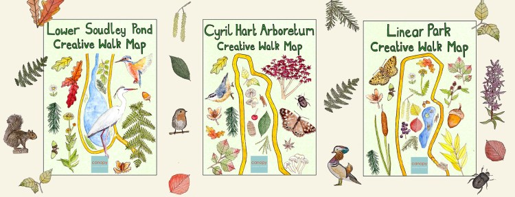
Over the last four years Canopy has developed a programme of Creative Walks in Nature, taking small groups out into the Forest with an experienced guide and artist leading the way. Thanks to funding from Forest of Dean District Council we have developed three new printed maps to complement these walks. The new beautifully illustrated maps feature three carefully designed routes aimed at those who may find walking challenging, offering a unique and creative approach to exploring the natural world.
Each mapped route is intentionally short (around 1 mile), focusing on the journey rather than the destination. The walks encourage wellbeing, creative thinking and a deeper connection with the environment through engaging points of reference along the way. By making nature more inviting and interactive, Canopy hopes to inspire more people to step outside and experience the benefits of nature easily and safely.
See each route and download the maps
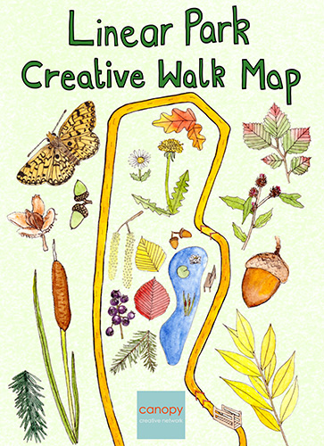
Linear Park
Linear Park is a wildlife conservation area with ponds, woodland, scrubland and reedbed. It follows part of an old railway line, starting at the old Ruspidge Halt railway station which is now the car park and borders the town of Cinderford to the east.
This is a short, flat wheelchair accessible route of less than a mile which takes in a small part of a much longer walk around Linear Park. A new path surface has recently been laid (January 2025).
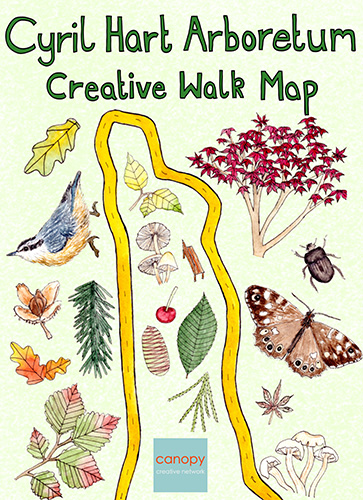
Cyril Hart Arboretum
The Cyril Hart Arboretum is home to over 200 tree species, some dating back to the early 1900s. The collection has been added to over the years and now contains species found around the world.
This is a short, flat route of less than a mile which takes in half of the arboretum.

Lower Soudley Pond
Soudley Ponds is a series of man-made ponds running along a secluded valley. It is a haven for wildlife and is designated as a Site of Special Scientific Interest (SSSI). The wetland habitat is home to lots of different plants, birds and insects.
This is a short, relatively flat route of 1 mile which takes in the lower of Soudley Ponds.
Pick up a printed map
Copies of the A3 folded maps will be available at a range of collections across the Forest of Dean over the coming weeks. Below are planned locations to be delivered to shortly and further locations will be added in due course. If you’d like copies or can help us distribute please get in contact!
Blakeney
- GP Practice
Bream
- GP Practice
- Library
Brockweir
- Shop
Cinderford
- Ow Bist/Forest Voluntary Action Forum
- Artspace
- Town Council/Library/The Belle Vue Centre
- The Wesley
- Medical Centre
- Pharmacies
Coleford
- Garden Centre
- Library/The Main Place
- Tourist Information Centre
- Coleford Welcomes Walkers
- Bells Hotel
- Forest Holidays
- Coleford Health Centre & Brunston Surgery
- The Speech House Hotel
Drybrook
- Church
- GP Practice
- Pharmacy
Gloucester
- Library
Gorsley
- Orchard Cafe
Lydney
- Library
- Town Hall
- Community Centre
- Health Centre
- Severnbanks Surgery
- Pharmacies
Mitcheldean
- GP Practice
- Library
- Pharmacy
- Church
- Vantage Point/Growth Hub
Monmouth
- Monmouth Tourist Information Centre
Newent
- GP Practice
- Library
- The Ark Cafe
- Sheppard House
Newnham
- The George Community Cafe
- Library
- Severnside B&B
Parkend
- Church
- Shop/cafe
Pillowell
- Chapel
Ross-on-Wye
- The Market House
Ruardean
- GP Practice
Ruspidge
- Memorial Hall
- New Inn Pub
Soudley
- Village Hall
- Dean Heritage Centre
- White Horse Pub
St Briavels
- Shop
- Pub
- Assembly Rooms
Yorkley
- Community Centre
Maps will also be distributed to care homes, schools, colleges, nurseries and day care centres throughout the Forest of Dean.
This project was made possible with funding from Forest of Dean District Council’s Active Travel Grant.
Press coverage included
BBC Gloucestershire, 16 March 2025: New maps to inspire accessible forest walks
The Forest and Wye Valley Review, 18 April 2025: Maps highlight walks accessible to everyone
